
Those of you who check out the NZ metservice website frequently, may remember last week’s ‘photo-of-the-week’:
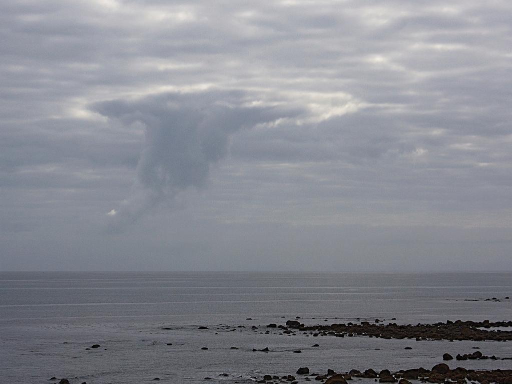
It’s of fallstreak cloud, and this example was spotted by my mother-in-law, Barbara Seccombe, off the coast from New Plymouth recently. (Photo credit to my father-in-law, Wally Seccombe, used with permission).
It’s not something you see everyday, so I asked my brother (Damian Wilson), who is a meteorologist in the UK, for an explanation. (N.B. – would-be meteorologists take note – you should be studying physics…) Here is Damian’s explanation, used with permission (It’s great when you can get other people to write your blog for you 😉 thanks guys!)
Very pretty. So you want to know what’s going on?
The layer of stratocumulus cloud you can see across the whole picture is composed of droplets of water, but it’s temperature is actually a few degrees below zero (probably around -5C to -10C). Water droplets can happily exist at these temperatures without freezing because there is no nucleation site for ice to start forming. If you think about ice on a car on a cold morning (I know, you’re still in the tail end of summer) you’ll recall there can be lots of fern like pattens – that’s because the ice couldn’t spontaneously form from the water, it needed somewhere to start forming, and it does this on molecular scale defects on the surface. But once a crystal of ice starts growing the molecules of water around it now have something to attach themselves to (the ice crystal itself) and will readily freeze to it. The result is several large crystals covering your car. Now, for a cloud droplet to freeze there must be something for it to nucleate on, and such particles are few and far between in the atmosphere – however, if you cool the cloud, the particles there are do become more effective at nucleating. And once you get nucleation at these temperatures, you’ll get ice crystals. And once you’ve got some ice crystals a little bit of thermodynamics that I won’t go into will ensure that the ice crystals grow further by "deposition" of water molecules from the air and the liquid water drops around them evaporate into the air. In effect, the ice crystals steal the molecules of water from the water droplets. Because there are so few nucleation sites, there are many fewer ice crystals than water droplets, with the result that they are much larger. And larger particles fall faster than small ones (because of air resistance).
So, what’s happened in the cloud in the photograph is that there has been an area of nucleation that has taken place. This is probably because something has caused the air to rise further than in the surrounding air – maybe a thermal of some sort. As the air rises, it expands (because the pressure gets less), it therefore cools and in this case has cooled to a temperature where substantial nucleation is able to start. And hence it has grown lots of ice particles, which are falling out, and are what you can see in the picture. These eventually evaporate (or melt) below the cloud.
Eventually you will end up with a large circular hole in the cloud.
Unless of course, this cloud is entirely above freezing, in which case there’s another method that will work, involving water droplets coalescing to form drizzle. This is a positive feedback type of process, once it gets going it will continue, with the effect that you can get regions of drizzle forming in areas that are otherwise drizzle free. But this picture looks more cloudy than drizzly, which is why I think it is ice.
Barbara Seccombe says:
Thank you Marcus for acknowledging that it was me who spotted that cloud. We have both enjoyed Damien’s explanation. Wally and I had set off for a walk and had stopped to watch a group of school children having their morning tea on some grass. When I looked up guess what I saw? At home group last night I mentioned this incident and Simon who is about nine was full of his cloud experiences. Next week I will show him Wally’s Cloud Appreciation Society book. We might have another scientist in the making!
Barbara